Silk and nature in Chirols
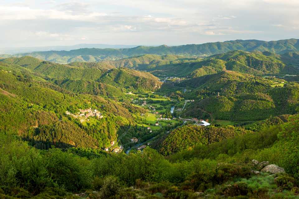
This walk peaks at 976m and Sainte Maguerite offers an exceptional 360° panorama on the mountains of Upper Cévennes, the highlands Ardèche, the Tanargue massif, the low Ardèche and by clear weather, the Ventoux Mount, the Alps and the Mont-Blanc.
Sainte Marguerite chapel is also a pilgrimage place, the first Sunday of septembre.
At the end of your walk, take the time to visit the “écomusée du moulinage” during the season, where you will discover, in the historical and industrial building, a beautiful museography that recount the silk thread chapters.
Description
Departure of the hike from the “Fournil des Co’pains”. Reach the post of the Veyrières bridge on 20m on your left.
 Follow the panel “Meyras 2.4km”. Continue on the calade, cross the road and take the path to Gonthier. Once, this track was taken by the inhabitants of the hamlets to reach their jobs places, the factory: the silkmill. In an exceptional setting, the visit of the “écomusée du moulinage” will make you discover the work of the silk thread.
- You are in Gonthier, follow the panel “Font Rognon 4.3km / Juvinas 7.1 km”. Nice view on the Veyrieres hamlet and on your back there is the Ventadour castle. Follow the track, cross once again the paved path that you will walk along a little further. Continue on the calade crossing the road many times to the house of Barricaud. From there, take the road on 50m approximately.
- Climb up the path on the left through the chestnuts to the Combe hamlet. Follow the street and cross the Aubignas and Rabeyrie hamlets to reach the col.
- You are now at Front Rognon, follow the “Vals les Bains 8,6 km” panel. Follow the road to Sainte Marguerite.
- You are in Sainte Marguerite, follow the panel “Vals les Bains 9.8 km”. Go down the way through the pines, to reach the track.
- You are on the track. Careful to take the second way on your right. Follow the way to the road.
- 100m after, and after the first houses of Roumégières, take the track on you right without crossing the hamlet then the calade that snakes to the chestnuts. You are arriving at Chirols village.
- Reach the town hall and take the calade on the right at the end of the parking area then continue on the route to Veyrières bridge.
- Departure : Veyrières bridge
- Arrival : Veyrières bridge
- Towns crossed : CHIROLS, JUVINAS, and VALS-LES-BAINS
Forecast
Altimetric profile
Recommandations
Information desks
Tourism Office
2 place du Bosquet, Neyrac les Bains, 07380 Meyras
Access and parking
From Aubenas take the N102 in Pont de Labeaume direction. At the end of the village, after the Rolandy bridge, take right in Montpezat-sous-Bauzon direction. At Veyrières bridge follow Chirols direction. At the first junction turn right.
From Thueyts, follow Montpezat-sous-Bauzon direction. At Veyrières bridge follow Chirols direction. At the first junction turn right.
Parking :
Report a problem or an error
If you have found an error on this page or if you have noticed any problems during your hike, please report them to us here: